Ground Tracking Antenna System
Ground Tracking Data Link Antenna for UAV and Airborne Platforms
Reliable, long range, two-way line-of-sight data, telemetry and video link between your ground control station and airborne platform, at ranges up to 250 km.
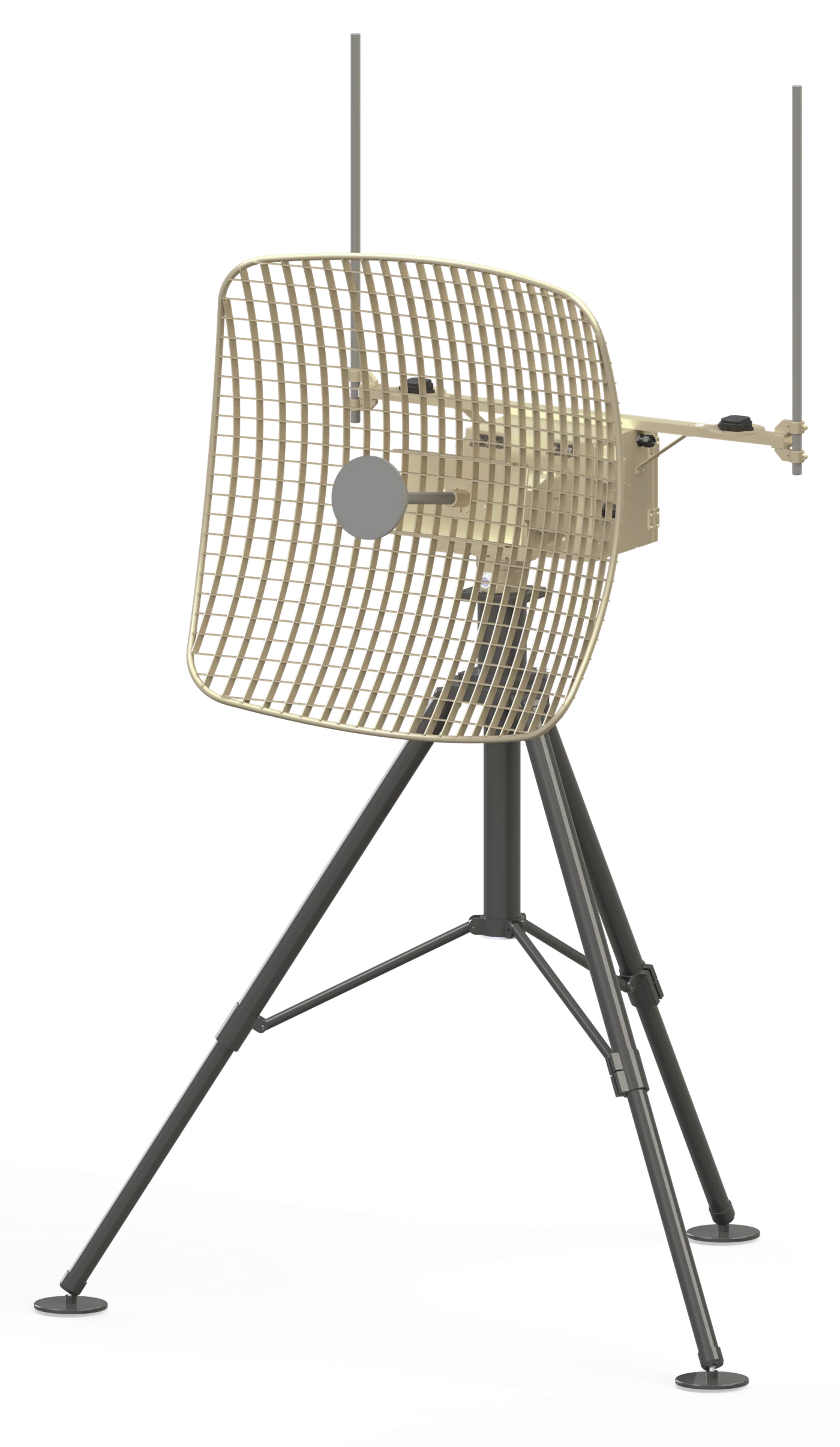
Stay locked on your UAV, from take-off to the horizon
A UAV mission is only as good as its link to the ground. Command uplink, telemetry and payload video all depend on the ground antenna staying accurately pointed at the aircraft, whatever the range, the altitude or the weather.
The SkyBeam Ground Tracking Antenna System keeps that link. Its high-gain directional reflector concentrates the signal toward the aircraft for a reliable two-way line-of-sight data, telemetry and video link at ranges up to 250 km. Two omni antennas cover take-off, landing and close-range flight, where the aircraft crosses the sky too quickly for a narrow beam.
The system points itself. An internal dual-antenna GPS finds its own position and true north at power-on, with no compass needed. Where the tripod or mast cannot be levelled, such as on sloped ground or an inclined mast, the platform angle is measured automatically during setup and up to ±10° of tilt is compensated. The ground control station then feeds the aircraft's GPS position and the precision pan-tilt unit keeps the reflector on target. If the position feed drops, RSSI tracking follows the aircraft by signal strength, so the link holds.
- Two-way LOS link up to 250 km
- Setup in under 10 minutes
- GPS tracking with RSSI backup
- Automatic true-north alignment
- ±10° tilt compensation for sloped ground
- UHF, L, S or C band reflector
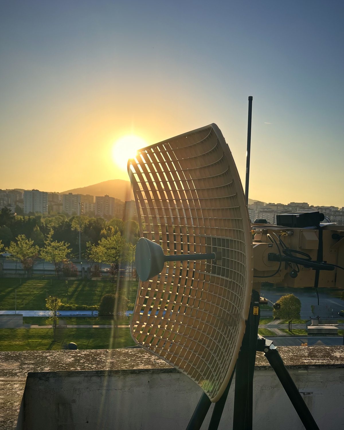
Built for the mission
Everything a ground segment needs to keep a reliable link with the aircraft: accurate pointing, automatic alignment, remote control and self-diagnostics, in one rugged system built for the field.
GPS + RSSI tracking
Points at the aircraft using its GPS position from the ground control station. If that feed is interrupted, RSSI tracking follows the aircraft by received signal strength and keeps the link alive.
North finding and tilt compensation
Internal dual-antenna GPS finds position and true north at power-on. On sloped ground or an inclined mast, the platform angle is measured automatically during setup and up to ±10° of tilt is compensated.
Multi-band options
UHF, L, S and C band directional antennas on the same pan-tilt platform, with reflector gain up to 30 dBi to suit the data link on your aircraft.
Low wind load reflector
The open grid reflector lets the wind pass through. The system keeps tracking in 80 km/h winds and survives 130 km/h, so exposed hilltop sites are not a problem.
Precision pan-tilt
Continuous 360° pan, -10° to +90° tilt and 60°/s on both axes for fast, close passes, with 0.02° pointing accuracy for the narrow C-band beam.
Web GUI + API
Control from any browser on the network, with separate admin and operator roles. An API lets your ground control station software drive the antenna directly.
Built-in health monitoring
Power-on, continuous and initiated built-in tests (PBIT / CBIT / IBIT), with live voltage, current and temperature readings, fan and filter life tracking and operational data logging downloadable from the web interface.
Military-grade design
Designed to MIL-STD-810G environmental and MIL-STD-461 EMI/EMC requirements for operation from -40 °C to +51 °C, with MIL-DTL-38999 connectors.
Ready to track in under 10 minutes
No survey, no alignment tools, no specialist on site. The system goes from its transport case to live tracking in four steps.
Set up
Set up and level the tripod or mast, mount the antenna and connect the 5 m cable harness and 28 VDC power.
Self-align
At power-on the system finds its position and true north. On sloped ground, up to ±10° of platform tilt is measured and compensated.
Connect
Connect your data link modem and ground control station. The aircraft's GPS position arrives over Ethernet.
Track
Start GPS Track from the web interface or through the API. The antenna turns to the aircraft and follows it throughout the mission.
Where it is used
Wherever an airborne platform needs a reliable, long range link to the ground, from fixed sites to forward operating locations.
Tactical and MALE UAV operations
Primary line-of-sight command, telemetry and video link for fixed-wing UAVs, from take-off to the edge of radio range.
Mobile ground control stations
Deploys next to a vehicle or shelter-based GCS, or on a mast that is not perfectly vertical and is ready again within minutes after every relocation, with no realignment.
Flight test and range instrumentation
Tracks test aircraft and airborne platforms for telemetry reception during development, qualification and acceptance flights.
Border and coastal surveillance
Keeps live payload video flowing from surveillance UAVs patrolling long borders and coastlines.
Payload video downlink
High-gain reception of EO/IR and sensor video from the aircraft for real-time situational awareness.
Extended-range missions
A second ground station along the flight route extends coverage beyond the line of sight of the first.
Match the antenna to your data link
One pan-tilt platform, four frequency bands. Choose the band that matches the data link on your aircraft; L-band is the standard configuration.
- Reflector
- 97 × 97 cm
- Beamwidth
- 15°
- Polarisation
- Dual linear
- Omni (×2)
- 7 dBi
- Reflector
- 97 × 64 cm
- Beamwidth
- 9° H · 13° V
- Polarisation
- Linear
- Omni (×2)
- 5 dBi
- Reflector
- 97 × 97 cm
- Beamwidth
- 4°
- Polarisation
- Dual linear
- Omni (×2)
- 2 dBi
- Antenna
- Directional
- Polarisation
- Linear
- VSWR
- 1.5:1
- Omni
- –
Choosing a band. Lower bands such as UHF and L-band have wider beams, are more forgiving of pointing errors and pass through foliage better. Higher bands such as S and C-band carry more bandwidth for high-definition video and the higher reflector gain makes up for the extra path loss. Not sure which fits your program? Tell us about your data link and our engineers will recommend a configuration.
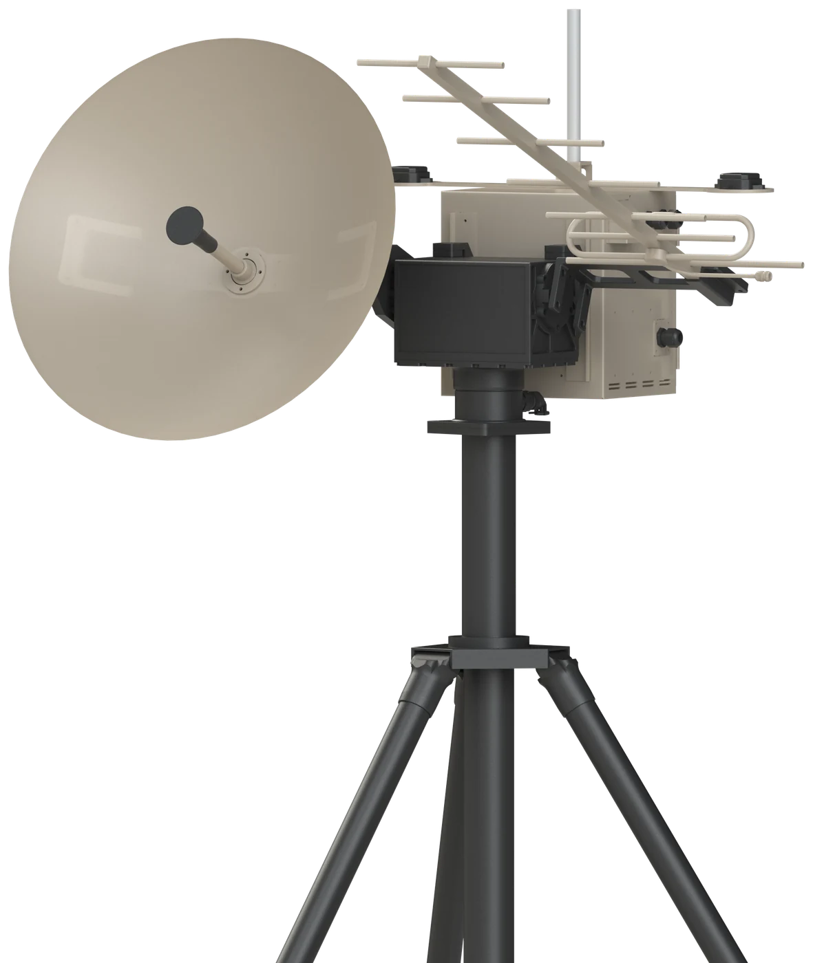
C-band and UHF on one pedestal
For programs that use both a C-band and a UHF data link, the system carries a C-band parabolic dish and a UHF directional antenna on the same pan-tilt unit. Both antennas point at the aircraft together, so a single tracking system serves both links.
Tracking, north finding, tilt compensation and the web interface are the same as in the single-band system.
| C-band directional | C-band omni | UHF directional | |
|---|---|---|---|
| Frequency | 4.40 – 5.00 GHz | 4.00 – 5.00 GHz | 400 – 480 MHz |
| Gain | ≥ 24 dBi | 2 dBi | ≥ 9 dBi |
| Antenna | Ø60 cm parabolic dish | Omni | Directional |
| Polarisation | Dual linear | Linear | Linear |
| VSWR | 2:1 | 1.5:1 | 1.5:1 |
| Impedance | 50 Ω | 50 Ω | 50 Ω |
Specifications
Full details are in the datasheet. Band-dependent values are listed under Antenna Options above.
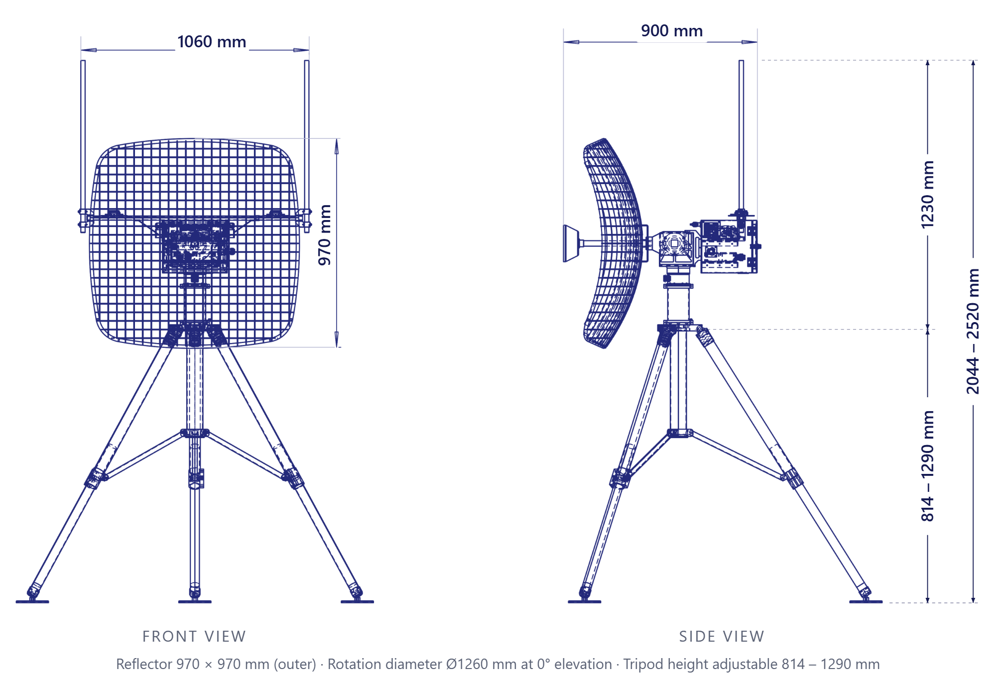
Pan-Tilt Unit
| Pan range | Unlimited (continuous 360°) |
| Pan / tilt speed | 60°/s |
| Tilt range | -10° to +90° |
| Pointing accuracy | 0.02° |
| Position feedback | 0.005° |
| Tilt compensation | ±10° (inclined ground or mast) |
Electrical & Interfaces
| Supply voltage | 28 VDC |
| Power consumption | 350 W max. |
| Ethernet | 1 × 100 Mbit (2 × optional) |
| Serial | 1 × RS-232, 2 × RS-422 |
| General-purpose I/O | 1 input, 2 outputs |
| Data / power connector | MIL-DTL-38999 |
Tripod
| Payload capacity | 100 kg |
| Height | 814 – 1290 mm (adjustable) |
| Weight | 13.2 kg |
Accessories
| Cabinet for ACU and other units · Wooden transport case · 5 m cable harness (modem not included) |
Mechanical
| Height (antenna system) | 1230 mm |
| Overall height (on tripod) | 2044 – 2520 mm |
| Rotation diameter (0° elevation) | Ø1260 mm |
| Weight | ~29 kg (without tripod) |
| Operating temperature | -40 °C to +51 °C |
| Wind, operational / survival | 80 / 130 km/h |
Environmental · MIL-STD-810G
| Low temperature | Method 502.5 |
| High temperature | Method 501.5 |
| Low pressure | Method 500.5 |
| Fluid contamination | Method 504.1 |
| Solar radiation | Method 505.5 |
| Rain | Method 506.5 |
| Humidity | Method 507.5 |
| Fungus | Method 508.6 |
| Salt fog | Method 509.5 |
| Sand and dust | Method 510.5 |
| Vibration | Method 514.6 |
| Shock | Method 516.6 |
| Icing / freezing rain | Method 521.3 |
EMI / EMC · MIL-STD-461
| CE102, CE106, CS101, CS103, CS104, CS105, CS114, CS115, CS116, RE102, RS103 |
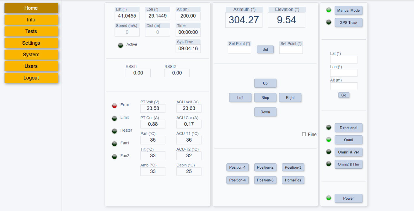
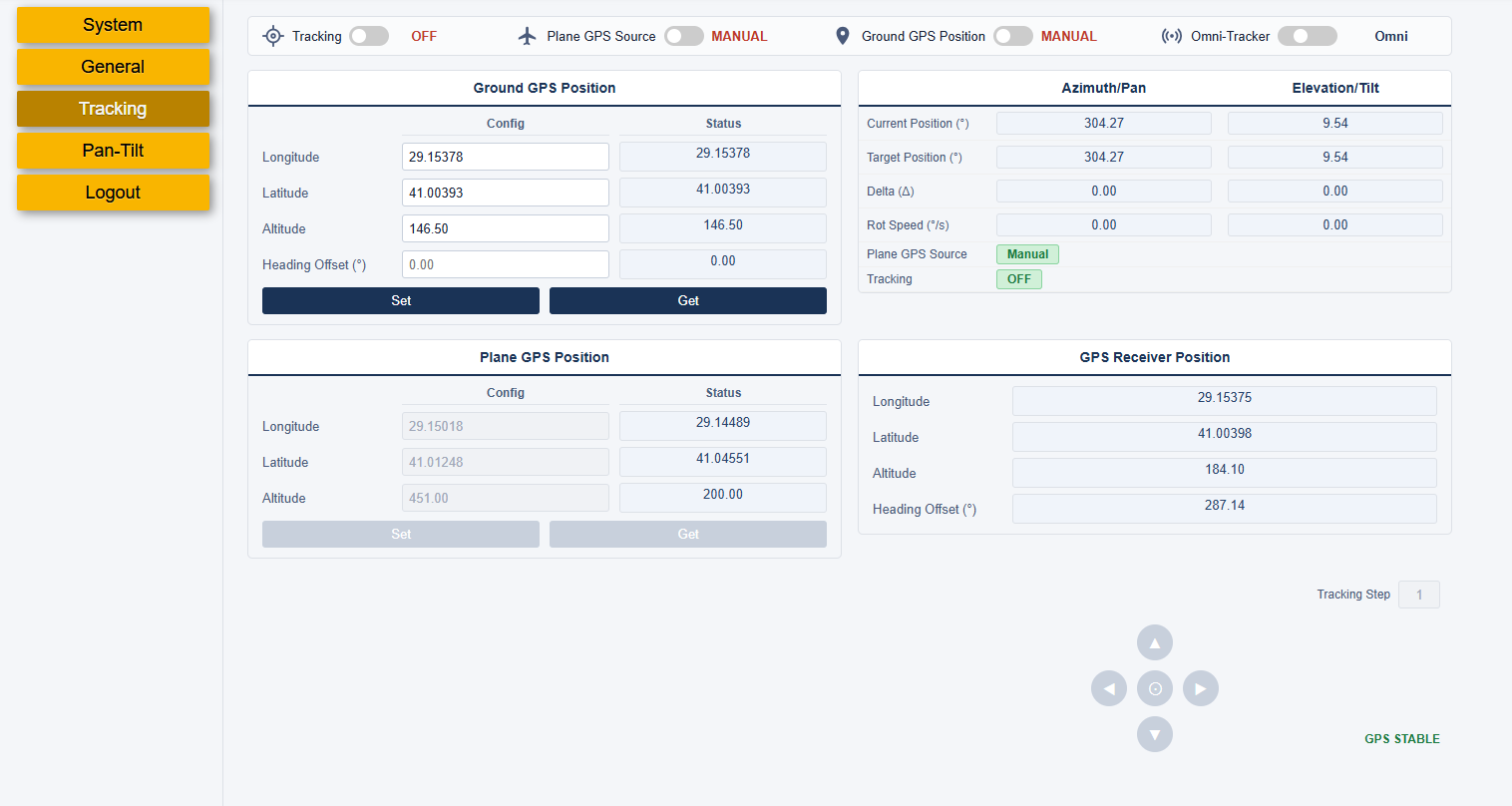
Control from any web browser
No software installation. Admins get full configuration, test and maintenance menus; operators get a simplified tracking screen.
From RF design to field deployment, engineered end-to-end
SkyBeam designs the antennas, the mechanics, the control electronics and the software of the Ground Tracking Antenna System itself. One team is responsible for the whole system, so RF performance, mechanics and tracking work as one.
It also means the system can be adapted. Band, reflector, interfaces and integration with your ground control station can be matched to your program.
- Complete system from one supplierAntennas, pan-tilt unit, control unit, cabling and transport case, delivered and tested as one system.
- Configured for your data linkUHF, L, S or C band reflectors and omni antennas to match the radio on your aircraft.
- Integration supportOur engineers help connect the system to your modem and ground control station software through the API.
- Trusted in defense programsSkyBeam antennas serve leading aerospace and defense companies.
Frequently asked questions
Which data links does it work with?
The antenna works with your existing data link modem in the UHF, L, S or C band; you choose the antenna option that matches its frequency. The modem itself is not included.
What happens if the aircraft's GPS data is lost?
The antenna switches to RSSI tracking and follows the aircraft by received signal strength, so the link is maintained until the GPS feed returns.
Does it need to be installed level?
The tripod or mast is normally levelled during setup. Where this is not possible, for example on sloped ground or an inclined mast, the platform angle is measured automatically during setup and the system compensates for up to ±10° of tilt, so pointing stays accurate.
How does it connect to our ground control station?
Over Ethernet. The GCS sends the aircraft's GPS position to the antenna and an API lets your software control it directly. RS-232 and RS-422 serial ports are also available.
How long does setup take?
Under 10 minutes from the transport case to tracking. North finding is automatic, so no compass or survey is needed.
What is delivered with the system?
The antenna system with pan-tilt unit and omni antennas, the tripod, a cabinet for the antenna control unit and other units, a 5 m cable harness and a wooden transport case.
What conditions can it operate in?
From -40 °C to +51 °C and in winds up to 80 km/h; it survives 130 km/h. It is designed to MIL-STD-810G and MIL-STD-461 requirements.
Does the system record operational data?
Yes. The system records operational logs at a configurable interval. The log file can be downloaded from the web interface for review and analysis.
Need a tracking antenna for your UAV program?
Tell us about your platform and data link. Our engineers will get back to you with configuration options, integration support and pricing.
info@skybeam.com.tr · +90 216 350 34 00
Your request has been received. Our team will get back to you shortly.
We have sent the datasheet to . It should arrive within a few minutes. If you do not see it, please check your spam folder.